
Weather doesn’t matter much when you’re sitting in an air conditioned/heated building…but in a disaster you’d better believe it will be right at the top of your priority list.
That’s why being able to read the weather (without the help of a weatherman or a cell phone) is a wilderness skill you absolutely must have.
Whether you’re getting started or could use a refresher, here are the things you need to know to effectively read the sky for weather.
KNOW HOW TO READ THE CLOUDS
Reading the weather mostly comes down to reading the clouds. Their shapes, colors, and behavior will tell you just about everything you need to know to get an accurate bead on incoming weather.
Cloud Position: The first thing to know is that clouds can be broken into four categories based on positioning:
- High clouds
- Middle clouds
- Low clouds
- Clouds with vertical growth
Cloud Shape: Then you’ve got three categories based on shape:
- Cumulus – A "heap" of clouds
- Stratus – Clouds that are long and streaky
- Nimbus – The shape of "rain" (because we all know what rain looks like)
Weather Changes Fast! Prepare with the Ready Hour 4-in-1 Emergency Solar Powered Weather Radio with Hand Crank!
HIGH CLOUDS
High clouds form at 16,000 to 43,000 feet. Basically, these are the clouds that you only encounter on the top of high mountains or at the cruising altitude of a jet airplane. Due to the extreme conditions at which they form, they tend to be comprised primarily of ice crystals.
High clouds do not block sunlight.
High clouds include:
- Cirrus
- Cirrostratus
- Cirrocumulus
CIRRUS

Cirrus clouds are white wispy clouds that stretch across the sky. By all accounts, cirrus clouds indicate fair weather in the immediate future. However, they can also be an indication of a change in weather patterns within the next 24 hours (most likely a change of pressure fronts).
By watching their movement and the direction in which the streaks are pointed, you can get a sense of which direction the weather front is moving.
CIRROSTRATUS

Cirrostratus tend to be sheet-like and cover the whole sky. You usually see the sun or moon through them. Their presence indicates moist weather within the next 12 - 24 hours.
CIRROCUMULUS

Cirrocumulus clouds are large groupings of white streaks that are sometimes seemingly neatly aligned. In most climates these mean fair weather for the near future.
Don't Get Left Out in the Storm. The Ready Hour 4-in-1 Emergency Weather Radio Has You Covered!
However, in the tropics, these clouds may indicate an approaching tropical storm or hurricane (depending on the season) and could be an indicator you need to prepare for a bad storm.
MIDDLE CLOUDS
Middle clouds form at 6,500 to 23,000 feet. They are comprised of water, and, if cold enough, ice.
Middle clouds often block sunlight, but not always.
Middle clouds consist of:
- Altostratus clouds
- Altocumulus clouds
ALTOSTRATUS

Altostratus are grey and/or blue clouds that cover the whole sky. They tend to indicate a storm some time in the very near future since they usually precede inclement weather.
ALTOCUMULUS

Altocumulus are grayish-white clouds blanketing the entire sky. The look like large fluffy sheets in which there is a lot of contrast between light and dark. Sun does not pass through them. If you see them in the morning, prepare for a thunderstorm in the afternoon.
LOW CLOUDS
Low clouds form below 6,500 feet. These clouds are the ones that like to hang around just above tall buildings. These clouds tend to contain water but can also be comprised of snow if the weather gets cold enough.
Low clouds block sunlight and can bring precipitation and wind.
Low clouds include:
- Stratus clouds
- Stratocumulus clouds
- Nimbostratus clouds
STRATUS

Stratus are low-lying solid clouds that are often formed when fog lifts off the ground. They obviously look like an elevated fog. Often, they bring drizzle or light snow.
STRATOCUMULUS

Stratocumulus are low-lying bumpy and grey clouds. They do not bring precipitation. They also do not cover the entire sky and tend to come in rows and patches.
NIMBOSTRATUS

Nimbostratus is your standard rain cloud. It is a large flat sheet of grey with a little bit of differentiation. If you see these, chances are it is raining outside.
When the Weather Takes a Turn for the Worse Make Sure You Have the Ready Hour 4-in-1 Emergency Solar Powered Weather Radio!
VERTICAL GROWTH
And last but not least are clouds with vertical growth. These tend to have a base that hangs really low (5,000 feet) and a top that climbs really high (over 50,000 feet).
- Clouds in this category include:
- Cumulus clouds
- Cumulonimbus clouds
CUMULUS
Cumulus clouds are your stereotypical white "cotton ball" clouds. So long as the clouds remain low clumps floating across the sky, there will be fair weather. However, you need to keep an eye on these clouds because any vertical growth can indicate the start of a large storm.
CUMULONIMBUS
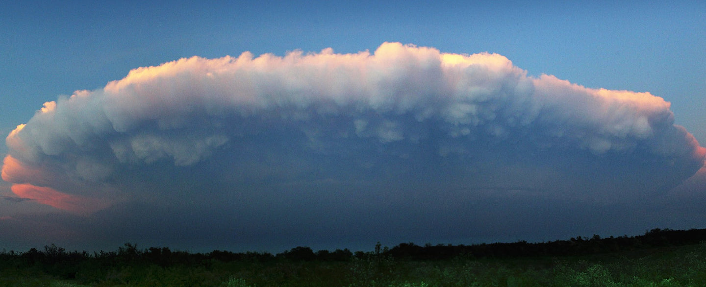
Cumulonimbus are cumulus clouds that have grown vertically into an anvil-like shape. The anvil tends to point in the direction the storm is moving. These clouds bring most dangerous weather such as rain, lightning, hail, tornadoes, and the problems that come with them (floods, power outages, etc.).
Now that you know what they look like and what to look for, you can easily determine what is going to happen when you look at the sky and can better prepare for your day.
8 comments
Very informative, thanks.
Thank you for this information. This was very informative. When hiking, traveling or even just at home I will use this to reference the possibilities of weather to come.
Very informative and useful! Thank you.